Doctor nearby Karl Dossche Hartchirurgie
Belgium
Doctor nearby Karl Dossche Hartchirurgie
Karl Dossche Hartchirurgie
Sint-Andriesdreef 20, Brugge België
contacts phone
:
+32
Latitude:
51.1714325
, Longitude:
3.1839744
read more
nearest Doctor
371 m
Auris
Kooidreef 6, Brugge
Doctor
read more
371 m
Verhoye-Samyn C.
Kooidreef 6, Brugge
Doctor
read more
552 m
Van Landuyt / Herman
Belgium
Doctor
read more
1.531 km
Hallyn / Dirk
Gentiaanstraat 4, Brugge
Doctor
read more
1.561 km
De Keyser / Jose
Graaf Pierre de Brieylaan 41, Brugge
Doctor
read more
1.597 km
De Craemer / Dirk
Ieperweg 23, Zedelgem
Doctor
read more
1.602 km
Delrue / Geertrui
Herfstlaan 17, Brugge
Doctor
read more
1.677 km
Arnout Hugo Vrj Brp
Spreeuwenweg 8, Zedelgem
Doctor
read more
1.894 km
Pieraerts / Paul
Stationsstraat 5, Zedelgem
Doctor
read more
1.984 km
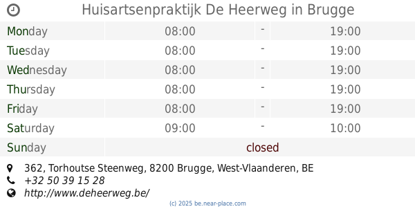
Huisartsenpraktijk De Heerweg
Torhoutse Steenweg 362, Brugge
Doctor
read more
2.002 km
Selleslag / Dominik
Hazelare 1, Zedelgem
Doctor
read more
2.048 km
Dr. De Smet
Olivier de Wreestraat 7, Brugge
Doctor
read more
2.101 km
Dermul / Anne
Karel Custisstraat 5, Brugge
Doctor
read more
2.103 km
Huisartsenpraktijk Tandem
Jachtveldstraat 6, Brugge
Doctor
read more
2.114 km
Dr R Kuhweide
Nieuwe Sint-Annadreef 40, Brugge
Doctor
read more
2.119 km
Van Hoeyweghen R.
Karel Custisstraat 11, Brugge
Doctor
read more
2.139 km
Vannerem/Luc
Doornstraat 235, Brugge
Doctor
read more
2.212 km
Vandevoorde / Paul
Jan van Hesestraat 5, Brugge
Doctor
read more
2.236 km
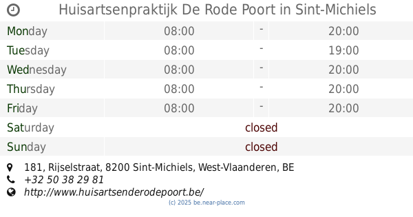
Huisartsenpraktijk De Rode Poort
Rijselstraat 181, Sint-Michiels
Doctor
read more
2.41 km
Praktijk Astrid
Koningin Astridlaan 17, Brugge
Doctor
read more
2.418 km
Gillemon / Luc
Koningin Astridlaan 17, Brugge
Doctor
read more
2.462 km
Delanote Joost
Notenbosdreef 1, Zedelgem
Doctor
read more
2.531 km
Themse Invest
Grote Thems 86, Jabbeke
Doctor
read more
2.598 km
Dokter Stefaan Colpaert
Veldstraat 2, Brugge
Doctor
read more
2.599 km
Soenen / Marc
Costersveld 16, Zedelgem
Doctor
read more
📑
all categories
Accounting
Administrative area level 1
Administrative area level 2
Airport
Amusement park
Aquarium
Art gallery
Atm
Bakery
Bank
Bar
Beauty salon
Bicycle store
Book store
Bowling alley
Bus station
Cafe
Campground
Car dealer
Car rental
Car repair
Car wash
Casino
Cemetery
Church
City hall
Clothing store
Colloquial area
Convenience store
Country
Courthouse
Dentist
Department store
Doctor
Electrician
Electronics store
Embassy
Finance
Fire station
Florist
Food
Funeral home
Furniture store
Gas station
General contractor
Grocery or supermarket
Gym
Hair care
Hardware store
Health
Hindu Temple
Home goods store
Hospital
Insurance agency
Jewelry store
Laundry
Lawyer
Library
Light rail station
Liquor store
Local government office
Locality
Locksmith
Lodging
Meal delivery
Meal takeaway
Mosque
Movie rental
Movie theater
Moving company
Museum
Natural feature
Neighborhood
Night club
Painter
Park
Parking
Pet store
Pharmacy
Physiotherapist
Place of worship
Plumber
Point of interest
Police
Political
Post office
Premise
Real estate agency
Restaurant
Roofing contractor
Route
Rv park, camping
School
Shoe store
Shopping mall
Spa
Stadium
Storage
Store
Subpremise
Subway station
Supermarket
Synagogue
Taxi stand
Train station
Transit station
Travel agency
University
Veterinary care
Zoo
sublocality level 1
sublocality level 2
sublocality level 3
↑