Doctor nearby Dr. Luc Proot - Algemene Chirurgie
Belgium
Doctor nearby Dr. Luc Proot - Algemene Chirurgie
Dr. Luc Proot - Algemene Chirurgie
Bosdreef 13, Oostkamp België
contacts phone
:
+32
Latitude:
51.1270676
, Longitude:
3.2159357
read more
nearest Doctor
360 m
Rogiers / Yolande
Lijsterbessendreef 17, Oostkamp
Doctor
read more
566 m
Verhaeghe Luc
Lijsterbessendreef 18, Oostkamp
Doctor
read more
782 m
Frank De Geeter
Veumedreef 10, Oostkamp
Doctor
read more
812 m
Rogiers / Philippe
Woestendreef 10, Oostkamp
Doctor
read more
1.892 km
Van De Walle / Christiaan
Kortrijksestraat 397, Oostkamp
Doctor
read more
2.387 km
Groepspraktijk De Bron
Legendaledreef 26, Oostkamp
Doctor
read more
2.486 km
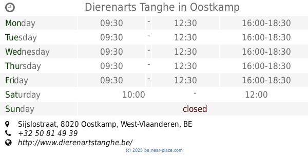
Dierenarts Tanghe
Sijslostraat, Oostkamp
Doctor
read more
2.595 km
Laukens Pierre
Klaprozenlaan 16, Zedelgem
Doctor
read more
2.889 km
Dokter Calmeyn Marc
Merkemveldweg 16, Zedelgem
Doctor
read more
3.099 km
Dr. Patrick Martens
Zeedijkweg 15, Zedelgem
Doctor
read more
3.129 km
Demeestere G.
Wollestraat 60, Oostkamp
Doctor
read more
3.462 km
Selleslag / Dominik
Hazelare 1, Zedelgem
Doctor
read more
3.551 km
Voetzaam
Bergenstraat 6, Oostkamp
Doctor
read more
3.555 km
Huisartspraktijk Dr.M.Vanpoucke-Dr.L.Depoorter
Brugsestraat 34, Oostkamp
Doctor
read more
3.557 km
Pattyn Karel huisarts
Vlamingstraat 15, Oostkamp
Doctor
read more
3.659 km
Podologie Kimberley Eecloo
Veldegemsestraat 144, Zedelgem
Doctor
read more
3.75 km
Arnout Hugo Vrj Brp
Spreeuwenweg 8, Zedelgem
Doctor
read more
3.831 km
De Craemer / Dirk
Ieperweg 23, Zedelgem
Doctor
read more
3.841 km
Baeke Johan
Sterredreef 2, Oostkamp
Doctor
read more
3.856 km
Decadt / Geert
Torhoutsestraat 48, Oostkamp
Doctor
read more
4.979 km
Soenen / Marc
Costersveld 16, Zedelgem
Doctor
read more
5.202 km
Gilon / Pascale
Tuinbouwstraat 4/A, Oostkamp
Doctor
read more
5.341 km
Deschutter Annelies, Docteur
Legeweg 76, Oostkamp
Doctor
read more
5.501 km
D'hoore / Pol
Legeweg 110, Oostkamp
Doctor
read more
5.686 km
Noyez Jan
Blauwhuisstraat 9, Oostkamp
Doctor
read more
📑
all categories
Accounting
Administrative area level 1
Administrative area level 2
Airport
Amusement park
Aquarium
Art gallery
Atm
Bakery
Bank
Bar
Beauty salon
Bicycle store
Book store
Bowling alley
Bus station
Cafe
Campground
Car dealer
Car rental
Car repair
Car wash
Casino
Cemetery
Church
City hall
Clothing store
Colloquial area
Convenience store
Country
Courthouse
Dentist
Department store
Doctor
Electrician
Electronics store
Embassy
Finance
Fire station
Florist
Food
Funeral home
Furniture store
Gas station
General contractor
Grocery or supermarket
Gym
Hair care
Hardware store
Health
Hindu Temple
Home goods store
Hospital
Insurance agency
Jewelry store
Laundry
Lawyer
Library
Light rail station
Liquor store
Local government office
Locality
Locksmith
Lodging
Meal delivery
Meal takeaway
Mosque
Movie rental
Movie theater
Moving company
Museum
Natural feature
Neighborhood
Night club
Painter
Park
Parking
Pet store
Pharmacy
Physiotherapist
Place of worship
Plumber
Point of interest
Police
Political
Post office
Premise
Real estate agency
Restaurant
Roofing contractor
Route
Rv park, camping
School
Shoe store
Shopping mall
Spa
Stadium
Storage
Store
Subpremise
Subway station
Supermarket
Synagogue
Taxi stand
Train station
Transit station
Travel agency
University
Veterinary care
Zoo
sublocality level 1
sublocality level 2
sublocality level 3
↑