Clothing store nearby vemor.be
Belgium
Clothing store nearby vemor.be
vemor.be
Geraardsbergsesteenweg 70, Aalst België
contacts phone
:
+32
Latitude:
50.9117339
, Longitude:
4.0292375
read more
nearest Clothing store
28 m
Noire de Noire
Geraardsbergsesteenweg 74, Erembodegem
Clothing store
read more
515 m
Vierendeels / Christoff
Ninovestraat 42/A, Haaltert
Clothing store
read more
1.933 km
Ohlala Fashion
Sint-Goriksplein 18, Haaltert
Clothing store
read more
2.024 km
Euro-Tricot bvba
Kerkhoflaan 52, Aalst
Clothing store
read more
2.078 km
Maggy Lingerie
Hoogstraat 19, Haaltert
Clothing store
read more
2.542 km
Kleding Anja
Hoogstraat 113, Haaltert
Clothing store
read more
2.836 km
M&B
Gentsesteenweg 8, Aalst
Clothing store
read more
2.844 km
Intro-Fashionstore
Steenweg 274, Denderleeuw
Clothing store
read more
2.901 km
Petit Prince bvba
Sint Jorisstraat 10, Aalst
Clothing store
read more
2.96 km
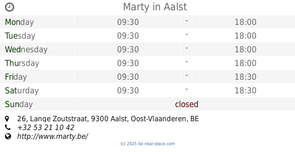
Marty
Lange Zoutstraat 26, Aalst
Clothing store
read more
2.969 km
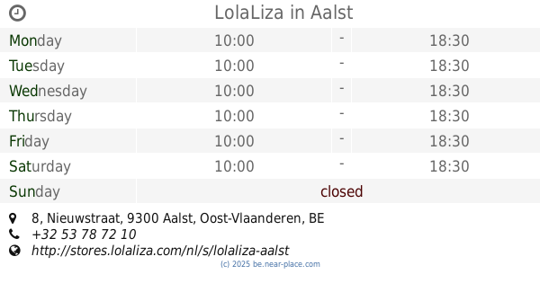
LolaLiza
Nieuwstraat 8, Aalst
Clothing store
read more
3.011 km
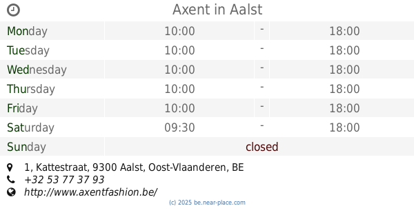
Axent
Kattestraat 1, Aalst
Clothing store
read more
3.012 km
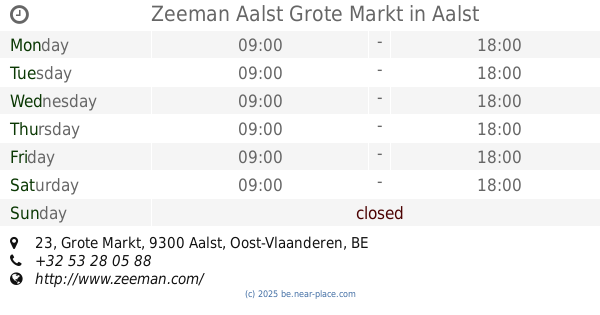
Zeeman Aalst Grote Markt
Grote Markt 23, Aalst
Clothing store
read more
3.026 km
H&M
Nieuwstraat 27-29, Aalst
Clothing store
read more
3.339 km
Cups lingerie
Steenweg 297, Denderleeuw
Clothing store
read more
📑
all categories
Accounting
Administrative area level 1
Administrative area level 2
Airport
Amusement park
Aquarium
Art gallery
Atm
Bakery
Bank
Bar
Beauty salon
Bicycle store
Book store
Bowling alley
Bus station
Cafe
Campground
Car dealer
Car rental
Car repair
Car wash
Casino
Cemetery
Church
City hall
Clothing store
Colloquial area
Convenience store
Country
Courthouse
Dentist
Department store
Doctor
Electrician
Electronics store
Embassy
Finance
Fire station
Florist
Food
Funeral home
Furniture store
Gas station
General contractor
Grocery or supermarket
Gym
Hair care
Hardware store
Health
Hindu Temple
Home goods store
Hospital
Insurance agency
Jewelry store
Laundry
Lawyer
Library
Light rail station
Liquor store
Local government office
Locality
Locksmith
Lodging
Meal delivery
Meal takeaway
Mosque
Movie rental
Movie theater
Moving company
Museum
Natural feature
Neighborhood
Night club
Painter
Park
Parking
Pet store
Pharmacy
Physiotherapist
Place of worship
Plumber
Point of interest
Police
Political
Post office
Premise
Real estate agency
Restaurant
Roofing contractor
Route
Rv park, camping
School
Shoe store
Shopping mall
Spa
Stadium
Storage
Store
Subpremise
Subway station
Supermarket
Synagogue
Taxi stand
Train station
Transit station
Travel agency
University
Veterinary care
Zoo
sublocality level 1
sublocality level 2
sublocality level 3
↑