City hall nearby Gemeente Moorslede
Coronavirus disease (COVID-19) Situation
confirmed cases
4861695
deaths
34376
Belgium
City hall nearby Gemeente Moorslede
Gemeente Moorslede
Marktplaats 1, Moorslede Belgium
contacts phone
:
+32
Latitude:
50.8912442
, Longitude:
3.0637525
read more
nearest City hall
8.937 km
Gemeentehuis Moorsele
Sint-Maartensplein 12, Wevelgem
City hall
read more
11.024 km
Stadhuis Izegem
Korenmarkt 10, Izegem
City hall
read more
12.335 km
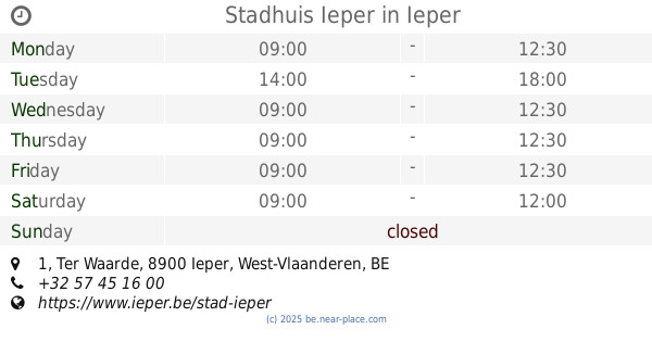
Stadhuis Ieper
Ter Waarde 1, Ieper
City hall
read more
12.388 km
municipal service Wevelgem
Vanackerestraat 12, Wevelgem
City hall
read more
12.554 km
Mairie
51 Rue Maurice Simono, Halluin
City hall
read more
12.747 km
Service éducation
Espace Vauban, Place du Général de Gaulle, Halluin
City hall
read more
12.775 km
Mairie
68 Rue de Lille, Halluin
City hall
read more
12.823 km
Chamois Marie
Rue Gabriel Péri, Halluin
City hall
read more
12.843 km
Middle School Du Sacré Coeur Halluin
26 Rue Marthe Nollet, Halluin
City hall
read more
12.846 km
Mairie
13 Rue Marthe Nollet, Halluin
City hall
read more
12.861 km
Mairie
60 Rue Marthe Nollet, Halluin
City hall
read more
13.223 km
Stadsbestuur Ieper
Grote Markt 34, Ieper
City hall
read more
13.223 km
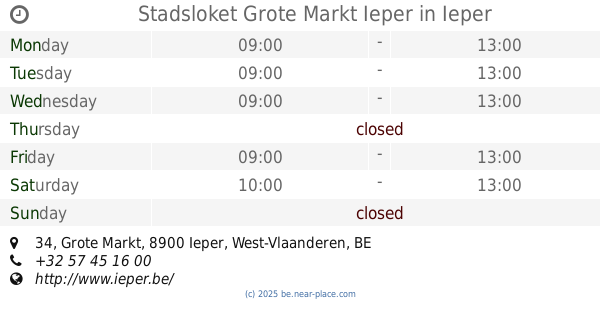
Stadsloket Grote Markt Ieper
Grote Markt 34, Ieper
City hall
read more
13.223 km
Hôtel de Ville d'Ypres
Grote Markt 34, Ieper
City hall
read more
13.268 km
Mairie - service petite enfance
6 Rue Arthur Dennetière, Halluin
City hall
read more
13.294 km
Mairie
19 Rue de Wervicq, Bousbecque
City hall
read more
13.381 km
Mairie de Wervicq Sud
50 Allée des Glycines, Wervicq-Sud
City hall
read more
13.389 km
Centre de PMI (Protection Maternelle et Infantile)
4 Ter Rue Arthur Dennetière, Halluin
City hall
read more
13.509 km
Gemeentebestuur Ardooie
Polenplein 15, Ardooie
City hall
read more
13.541 km
Gemeentehuis
Polenplein 15, Ardooie
City hall
read more
14.387 km
Mairie
1 Rue des Maires Lambin, Comines
City hall
read more
14.541 km
Heritage House
4/6 Rue Pont, Comines
City hall
read more
14.797 km
Mairie
9 Rue Gambetta, Comines
City hall
read more
15.706 km
Stadhuis Kortrijk
Leiestraat 21, Kortrijk
City hall
read more
18.305 km
Pittem
Markt 1, Pittem
City hall
read more
📑
all categories
Accounting
Administrative area level 1
Administrative area level 2
Airport
Amusement park
Aquarium
Art gallery
Atm
Bakery
Bank
Bar
Beauty salon
Bicycle store
Book store
Bowling alley
Bus station
Cafe
Campground
Car dealer
Car rental
Car repair
Car wash
Casino
Cemetery
Church
City hall
Clothing store
Colloquial area
Convenience store
Country
Courthouse
Dentist
Department store
Doctor
Electrician
Electronics store
Embassy
Finance
Fire station
Florist
Food
Funeral home
Furniture store
Gas station
General contractor
Grocery or supermarket
Gym
Hair care
Hardware store
Health
Hindu Temple
Home goods store
Hospital
Insurance agency
Jewelry store
Laundry
Lawyer
Library
Light rail station
Liquor store
Local government office
Locality
Locksmith
Lodging
Meal delivery
Meal takeaway
Mosque
Movie rental
Movie theater
Moving company
Museum
Natural feature
Neighborhood
Night club
Painter
Park
Parking
Pet store
Pharmacy
Physiotherapist
Place of worship
Plumber
Point of interest
Police
Political
Post office
Premise
Real estate agency
Restaurant
Roofing contractor
Route
Rv park, camping
School
Shoe store
Shopping mall
Spa
Stadium
Storage
Store
Subpremise
Subway station
Supermarket
Synagogue
Taxi stand
Train station
Transit station
Travel agency
University
Veterinary care
Zoo
sublocality level 1
sublocality level 2
sublocality level 3
↑