Church nearby Sint-Pietersstoelkerk
Belgium
Church nearby Sint-Pietersstoelkerk
Sint-Pietersstoelkerk
20, Moregemplein, 9790, Wortegem-Petegem, Oost-Vlaanderen, BE Belgium
contacts phone
:
+32
website:
inventaris.onroerenderfgoed.be
Latitude:
50.8503389
, Longitude:
3.562303
larger map & directions
read more
nearest Church
602 m
Kapel OLV Ten Doorn
Heerbaan 6a, Wortegem-Petegem
Church
read more
1.943 km
Sint-Martinuskerk
Petegemplein, Petegem
Church
read more
2.298 km
Sint-Pieterskerk Bevere
Wortegemstraat, Oudenaarde
Church
read more
2.393 km
Sint-Amanduskerk Ooike
Ooikeplein, Wortegem-Petegem
Church
read more
2.681 km
Kapel Onze-Lieve-Vrouw van Fatima
9700, Oudenaarde
Church
read more
2.973 km
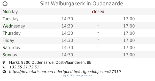
Sint-Walburgakerk
Markt, Oudenaarde
Church
read more
3.168 km
Evangeliche gemeenschap oudenaarde
Blekerijstraat 15, Oudenaarde
Church
read more
3.363 km
O.L.V. Geboortekerk Pamele
Pamelekerkplein, Oudenaarde
Church
read more
3.363 km
Onze-Lieve-Vrouwekerk
Pamelekerkplein, Oudenaarde
Church
read more
3.424 km
Schipperskerkje
Jan Baptist Eeckhoutskaai 12, Oudenaarde
Church
read more
3.43 km
Sint-Mauruskerk
Elsegemplein 13, Elsegem
Church
read more
3.454 km
Sint-Jozefkerk
Sint-Jozefsplein 8, Oudenaarde
Church
read more
3.508 km
Sint-Amanduskerk Leupegem
Ronseweg, Oudenaarde
Church
read more
3.702 km
Onze-Lieve-Vrouw Geboortekerk
Wortegemplein, Wortegem
Church
read more
4.462 km
Sint-Dionysiuskerk
Lededorp 1-11, Kruishoutem
Church
read more
4.497 km
Sint-Machutuskerk
Huisepontweg 2, Kruishoutem
Church
read more
4.596 km
Sint-Martinuskerk Edelare
Edelareberg 63, Oudenaarde
Church
read more
4.646 km
Sint-Elligiuskerk Eine
Eineplein, Oudenaarde
Church
read more
4.929 km
Sint-Laurentiuskerk Ename
Paardemarktstraat, Oudenaarde
Church
read more
5.238 km
de kapel van Kerselare
Oudenaarde
Church
read more
5.3 km
Sint-Vedastuskerk Nederename
Ohiostraat, Oudenaarde
Church
read more
5.312 km
Kapel van de Vrede
9700, Oudenaarde
Church
read more
5.312 km
Lombaertskapel
Turkestraat 2-6, Kruishoutem
Church
read more
5.873 km
Sint-Amanduskerk Heurne
Heurnestraat, Oudenaarde
Church
read more
6.171 km
Sint-Britiuskerk Etikhove
Etikhovestraat, Maarkedal
Church
read more
📑
all categories
Accounting
Administrative area level 1
Administrative area level 2
Airport
Amusement park
Aquarium
Art gallery
Atm
Bakery
Bank
Bar
Beauty salon
Bicycle store
Book store
Bowling alley
Bus station
Cafe
Campground
Car dealer
Car rental
Car repair
Car wash
Casino
Cemetery
Church
City hall
Clothing store
Colloquial area
Convenience store
Country
Courthouse
Dentist
Department store
Doctor
Electrician
Electronics store
Embassy
Finance
Fire station
Florist
Food
Funeral home
Furniture store
Gas station
General contractor
Grocery or supermarket
Gym
Hair care
Hardware store
Health
Hindu Temple
Home goods store
Hospital
Insurance agency
Jewelry store
Laundry
Lawyer
Library
Light rail station
Liquor store
Local government office
Locality
Locksmith
Lodging
Meal delivery
Meal takeaway
Mosque
Movie rental
Movie theater
Moving company
Museum
Natural feature
Neighborhood
Night club
Painter
Park
Parking
Pet store
Pharmacy
Physiotherapist
Place of worship
Plumber
Point of interest
Police
Political
Post office
Premise
Real estate agency
Restaurant
Roofing contractor
Route
Rv park, camping
School
Shoe store
Shopping mall
Spa
Stadium
Storage
Store
Subpremise
Subway station
Supermarket
Synagogue
Taxi stand
Train station
Transit station
Travel agency
University
Veterinary care
Zoo
sublocality level 1
sublocality level 2
sublocality level 3
↑