Cafe nearby The Pepsi
Coronavirus disease (COVID-19) Situation
confirmed cases
4861695
deaths
34376
Belgium
Cafe nearby The Pepsi
The Pepsi
Voskenslaan 64, Gent Bélgica
contacts phone
:
+32
Latitude:
51.0327739
, Longitude:
3.7075525
read more
nearest Cafe
174 m
The Zone
Voskenslaan 135, Gent
Cafe
read more
350 m
De Passage
Sint-Denijslaan 129, Gent
Cafe
read more
363 m
Candy & Sandwich Bar
1, Gent
Cafe
read more
408 m
Java Coffee House
Schoonmeersstraat 52, Gent
Cafe
read more
417 m
Milk Bar
Ghent
Cafe
read more
421 m
Coffeehouse Schoonmeersen
Schoonmeersstraat 52, Gent
Cafe
read more
435 m
New Castle VOF
Kortrijksesteenweg 606, Gent
Cafe
read more
441 m
Koffiebar
Koningin Fabiolalaan 1, Gent
Cafe
read more
447 m
Einstein Coffee
Sint-Pietersstation, Gent
Cafe
read more
449 m
Starbucks
Gent Sint Pieters Station, Koningin Maria Hendrikaplein 1, Gent
Cafe
read more
471 m
Bij Lucy
Prinses Clementinalaan 203, Gent
Cafe
read more
516 m
Cafe De Klok
Koning Boudewijnstraat 1, Gent
Cafe
read more
516 m
Brasserie Zina
66, Koningin Maria Hendrikaplein, Gent
Cafe
read more
536 m
Chapter One
Koningin Maria Hendrikaplein 54, Gent
Cafe
read more
572 m
New Watson
Koningin Elisabethlaan 150, Gent
Cafe
read more
573 m
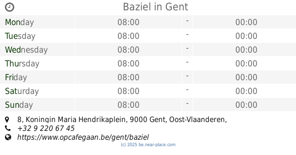
Baziel
Koningin Maria Hendrikaplein 8, Gent
Cafe
read more
696 m
't Frietpaleis
Koningin Elisabethlaan 60, Gent
Cafe
read more
717 m
Farao's
Parklaan 135, Gent
Cafe
read more
733 m
Ijs-ster
Rijsenbergstraat 8, Gent
Cafe
read more
758 m
Chick 'n Dale food truck
Koning Leopold II-laan 183, Gent
Cafe
read more
872 m
Vivaldi
Kortrijksesteenweg 265, Gent
Cafe
read more
959 m
lore
Koningin Fabiolalaan, Gent
Cafe
read more
963 m
De Natuurlijke Weg Van Thee
Paul Fredericqstraat 24, Gent
Cafe
read more
1.258 km
Affandina
Kortrijksesteenweg 5, Gent
Cafe
read more
1.792 km
Seven
9000, Gent
Cafe
read more
📑
all categories
Accounting
Administrative area level 1
Administrative area level 2
Airport
Amusement park
Aquarium
Art gallery
Atm
Bakery
Bank
Bar
Beauty salon
Bicycle store
Book store
Bowling alley
Bus station
Cafe
Campground
Car dealer
Car rental
Car repair
Car wash
Casino
Cemetery
Church
City hall
Clothing store
Colloquial area
Convenience store
Country
Courthouse
Dentist
Department store
Doctor
Electrician
Electronics store
Embassy
Finance
Fire station
Florist
Food
Funeral home
Furniture store
Gas station
General contractor
Grocery or supermarket
Gym
Hair care
Hardware store
Health
Hindu Temple
Home goods store
Hospital
Insurance agency
Jewelry store
Laundry
Lawyer
Library
Light rail station
Liquor store
Local government office
Locality
Locksmith
Lodging
Meal delivery
Meal takeaway
Mosque
Movie rental
Movie theater
Moving company
Museum
Natural feature
Neighborhood
Night club
Painter
Park
Parking
Pet store
Pharmacy
Physiotherapist
Place of worship
Plumber
Point of interest
Police
Political
Post office
Premise
Real estate agency
Restaurant
Roofing contractor
Route
Rv park, camping
School
Shoe store
Shopping mall
Spa
Stadium
Storage
Store
Subpremise
Subway station
Supermarket
Synagogue
Taxi stand
Train station
Transit station
Travel agency
University
Veterinary care
Zoo
sublocality level 1
sublocality level 2
sublocality level 3
↑