Cafe nearby Starbucks
Coronavirus disease (COVID-19) Situation
confirmed cases
4861695
deaths
34376
Belgium
Cafe nearby Starbucks
Starbucks
Louizalaan, 1000, Brussel, BE Belgium
contacts phone
:
+32 2 537 18 60
website:
www.starbucks.com
Latitude:
50.8357836
, Longitude:
4.3552379
larger map & directions
read more
nearest Cafe
233 m
Coffe Shop Vergnano 1882
Brussels
Cafe
read more
272 m
Maison Dandoy - Louise
Place Stéphanie 4, Ixelles
Cafe
read more
412 m
Café Capitale
1000, Rue Ernest Allard 41, Bruxelles
Cafe
read more
459 m
Bruxelles Luxembourg
Gulden-Vlieslaan 11, Brussel
Cafe
read more
525 m
Het Warm Water
Vossenstraat 25, Brussel
Cafe
read more
586 m
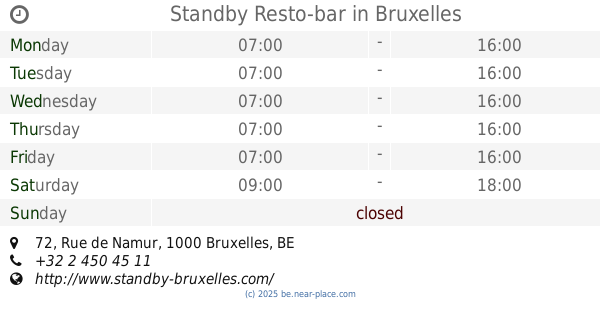
Standby Resto-bar
Rue de Namur 72, Bruxelles
Cafe
read more
623 m
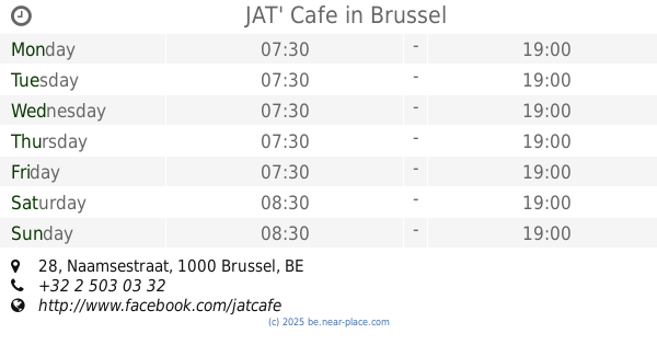
JAT' Cafe
Naamsestraat 28, Brussel
Cafe
read more
643 m
Marcel Bike Café
Georges Matheusstraat 43, Sint-Joost-ten-Node
Cafe
read more
848 m
Potemkine
Hallepoortlaan 2, Sint-Gillis
Cafe
read more
848 m
Cafe Le Coq
Fernand Cocqplein 25, Elsene
Cafe
read more
852 m
Regence (La)
Fernand Cocqplein 12, Elsene
Cafe
read more
865 m
Workshop Café
Avenue Louise 146, Ixelles
Cafe
read more
899 m
l'atelier du sandwich
Gerechtsplein 23, Brussel
Cafe
read more
899 m
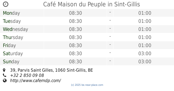
Café Maison du Peuple
Parvis Saint Gilles 39, Sint-Gillis
Cafe
read more
951 m
Brasserie Athoise
Zuidlaan 90, Brussel
Cafe
read more
979 m
Caffelatte Espressobar
Handelsstraat 19, Brussel
Cafe
read more
984 m
Laurent Gerbaud
Rue Ravenstein 12, Bruxelles
Cafe
read more
992 m
Caféabc (EAT vzw)
Rue Philippe de Champagne 23, Bruxelles
Cafe
read more
993 m
Santana Cafe
Place Rouppe 24, Bruxelles
Cafe
read more
993 m
Parvis 13
Parvis Saint-Gilles 11, Saint-Gilles
Cafe
read more
1.091 km
Sabor & Ar
Retoricastraat 16-2, Sint-Gillis
Cafe
read more
1.124 km
Natural caffè Louise
Louizalaan 196A, Brussel
Cafe
read more
1.241 km
Café ZERO GRAU
Fortstraat 51, Sint-Gillis
Cafe
read more
1.241 km
Café ZERO GRAU
Rue du Fort 51, Saint-Gilles
Cafe
read more
1.314 km
Cartea-Gomez / M.
Fortstraat 78, Sint-Gillis
Cafe
read more
📑
all categories
Accounting
Administrative area level 1
Administrative area level 2
Airport
Amusement park
Aquarium
Art gallery
Atm
Bakery
Bank
Bar
Beauty salon
Bicycle store
Book store
Bowling alley
Bus station
Cafe
Campground
Car dealer
Car rental
Car repair
Car wash
Casino
Cemetery
Church
City hall
Clothing store
Colloquial area
Convenience store
Country
Courthouse
Dentist
Department store
Doctor
Electrician
Electronics store
Embassy
Finance
Fire station
Florist
Food
Funeral home
Furniture store
Gas station
General contractor
Grocery or supermarket
Gym
Hair care
Hardware store
Health
Hindu Temple
Home goods store
Hospital
Insurance agency
Jewelry store
Laundry
Lawyer
Library
Light rail station
Liquor store
Local government office
Locality
Locksmith
Lodging
Meal delivery
Meal takeaway
Mosque
Movie rental
Movie theater
Moving company
Museum
Natural feature
Neighborhood
Night club
Painter
Park
Parking
Pet store
Pharmacy
Physiotherapist
Place of worship
Plumber
Point of interest
Police
Political
Post office
Premise
Real estate agency
Restaurant
Roofing contractor
Route
Rv park, camping
School
Shoe store
Shopping mall
Spa
Stadium
Storage
Store
Subpremise
Subway station
Supermarket
Synagogue
Taxi stand
Train station
Transit station
Travel agency
University
Veterinary care
Zoo
sublocality level 1
sublocality level 2
sublocality level 3
↑