Cafe nearby Stampertje
Belgium
Cafe nearby Stampertje
Stampertje
Lakerweg 58, Kinrooi Belgien
contacts phone
:
+32
Latitude:
51.14612
, Longitude:
5.774081
read more
nearest Cafe
217 m
Cafe de grenshook
Manestraat 16, Kinrooi
Cafe
read more
2.355 km
Zasada / Dorota
Neeroetersesteenweg 38, Kinrooi
Cafe
read more
2.438 km
Taverne De Schans Kinrooi
Nelisveld 13, Kinrooi
Cafe
read more
2.466 km
Cafe De Knup
Breeërsteenweg 11-21, Kinrooi
Cafe
read more
2.702 km
V.O.F. Scheepers-Hansen
Bosstraat 10, Neeritter
Cafe
read more
2.843 km
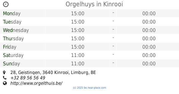
Orgelhuys
Geistingen 28, Kinrooi
Cafe
read more
2.885 km
Cafe Beej Nelis
Vroenhof 5, Kinrooi
Cafe
read more
2.96 km
Café-Friture de Heerlijckheid
Lambertusstraat 50, Neeritter
Cafe
read more
2.998 km
Café De Bierhemel
Venlosesteenweg 83, Kinrooi
Cafe
read more
3.864 km
Ophoven, Sailcenter
Kinrooi
Cafe
read more
4.241 km
Tropicana
Venlosesteenweg 142, Maaseik
Cafe
read more
4.626 km
De Sjeiven Dörpel
Leeuwerikstraat 74, Maaseik
Cafe
read more
4.693 km
Buisman Place
Irisstraat 17, Ittervoort
Cafe
read more
5.006 km
Bruin cafe De Zonnewyzer
Hoogstraat 18, Thorn
Cafe
read more
5.197 km
't Kapelhuis
Heerbaan-Kapel 2, Thorn
Cafe
read more
5.228 km
Café De Pegel
Eind 5, Thorn
Cafe
read more
5.239 km
V.O.F. Aod Thoear
Steegputstraat 4, Thorn
Cafe
read more
5.286 km
cafezaal D'n Ingel
Schoolstraat 20, Thorn
Cafe
read more
5.286 km
Café D'n Ingel
Schoolstraat 20, Thorn
Cafe
read more
5.72 km
Het Kruisveld
Bosstraat 54, Maaseik
Cafe
read more
5.872 km
In 't Gulden Aanbeeld
Markt 10, Maaseik
Cafe
read more
7.781 km
Café Zaal De Harmonie
Wallenstraat 7, Wessem
Cafe
read more
8.185 km
Herberg De Markt
Molenweg 30, Maasbracht
Cafe
read more
13.883 km
Zaal Astrid
Maasstraat 2-6, Dilsen-Stokkem
Cafe
read more
14.19 km
Stadcafé Feesthal De Kring
A. Sauwenlaan 90, Dilsen-Stokkem
Cafe
read more
📑
all categories
Accounting
Administrative area level 1
Administrative area level 2
Airport
Amusement park
Aquarium
Art gallery
Atm
Bakery
Bank
Bar
Beauty salon
Bicycle store
Book store
Bowling alley
Bus station
Cafe
Campground
Car dealer
Car rental
Car repair
Car wash
Casino
Cemetery
Church
City hall
Clothing store
Colloquial area
Convenience store
Country
Courthouse
Dentist
Department store
Doctor
Electrician
Electronics store
Embassy
Finance
Fire station
Florist
Food
Funeral home
Furniture store
Gas station
General contractor
Grocery or supermarket
Gym
Hair care
Hardware store
Health
Hindu Temple
Home goods store
Hospital
Insurance agency
Jewelry store
Laundry
Lawyer
Library
Light rail station
Liquor store
Local government office
Locality
Locksmith
Lodging
Meal delivery
Meal takeaway
Mosque
Movie rental
Movie theater
Moving company
Museum
Natural feature
Neighborhood
Night club
Painter
Park
Parking
Pet store
Pharmacy
Physiotherapist
Place of worship
Plumber
Point of interest
Police
Political
Post office
Premise
Real estate agency
Restaurant
Roofing contractor
Route
Rv park, camping
School
Shoe store
Shopping mall
Spa
Stadium
Storage
Store
Subpremise
Subway station
Supermarket
Synagogue
Taxi stand
Train station
Transit station
Travel agency
University
Veterinary care
Zoo
sublocality level 1
sublocality level 2
sublocality level 3
↑