Cafe nearby L éspérance (chez Bernard)
Coronavirus disease (COVID-19) Situation
confirmed cases
4861695
deaths
34376
Belgium
Cafe nearby L éspérance (chez Bernard)
L éspérance (chez Bernard)
Place Jourdan 47, Etterbeek Belgium
contacts phone
:
+32
Latitude:
50.837012
, Longitude:
4.3810115
read more
nearest Cafe
75 m
Studio Frankie
Place Jourdan 13a, Etterbeek
Cafe
read more
301 m
CaféVaria
Scepterstraat 78, Elsene
Cafe
read more
560 m
Cherry Delicatessen
Steenweg op Etterbeek 66, Brussel
Cafe
read more
561 m
Cafe Felix
Chaussée de Wavre 558, Etterbeek
Cafe
read more
586 m
Brasserie 1898
Avenue d'Auderghem 4, Bruxelles
Cafe
read more
586 m
Brasserie 1898
Oudergemlaan 4, Brussel
Cafe
read more
622 m
Starbucks
Robert Schumanplein, Brussel
Cafe
read more
648 m
Charles / Philippe
Luxemburgplein 12, Elsene
Cafe
read more
677 m
Lav
Steenweg op Etterbeek 56, Brussel
Cafe
read more
686 m
Tout Bon
Rue du Luxembourg 68, Bruxelles
Cafe
read more
754 m
Corica Quartier Européen
Rue Caroly 39, Ixelles
Cafe
read more
754 m
Corica Quartier Européen
Carolystraat 39, Elsene
Cafe
read more
761 m
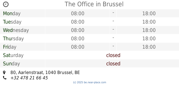
The Office
Aarlenstraat 80, Brussel
Cafe
read more
811 m
Aux Sans Souci
Rue du Viaduc Rue du Viaduc, Ixelles
Cafe
read more
860 m
Pastry Garcia
Avenue de la Couronne 75-77, Ixelles
Cafe
read more
912 m
Carrefour de la chasse
Rue Général Wangermée 1, Etterbeek
Cafe
read more
926 m
Chilli's Food - Maelbeek
Rue Joseph II 96, Bruxelles
Cafe
read more
946 m
Autoworld Brasserie
Jubelpark 11, Brussel
Cafe
read more
950 m
La VICTOIRE
Avenue Eudore Pirmez 12, Etterbeek
Cafe
read more
968 m
Brasserie de la chasse Avenue de la chasse 9 etterbeek
Avenue de la Chasse 9, Etterbeek
Cafe
read more
1.007 km
Caffelatte Espressobar
Handelsstraat 19, Brussel
Cafe
read more
1.024 km
Bar Athénée
Jules Bouillonstraat 2, Elsene
Cafe
read more
1.106 km
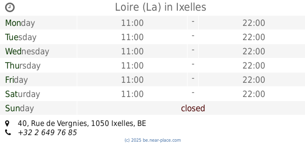
Loire (La)
Rue de Vergnies 40, Ixelles
Cafe
read more
1.136 km
Total
Rue du Commerce 93, Bruxelles
Cafe
read more
1.186 km
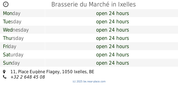
Brasserie du Marché
Place Eugène Flagey 11, Ixelles
Cafe
read more
📑
all categories
Accounting
Administrative area level 1
Administrative area level 2
Airport
Amusement park
Aquarium
Art gallery
Atm
Bakery
Bank
Bar
Beauty salon
Bicycle store
Book store
Bowling alley
Bus station
Cafe
Campground
Car dealer
Car rental
Car repair
Car wash
Casino
Cemetery
Church
City hall
Clothing store
Colloquial area
Convenience store
Country
Courthouse
Dentist
Department store
Doctor
Electrician
Electronics store
Embassy
Finance
Fire station
Florist
Food
Funeral home
Furniture store
Gas station
General contractor
Grocery or supermarket
Gym
Hair care
Hardware store
Health
Hindu Temple
Home goods store
Hospital
Insurance agency
Jewelry store
Laundry
Lawyer
Library
Light rail station
Liquor store
Local government office
Locality
Locksmith
Lodging
Meal delivery
Meal takeaway
Mosque
Movie rental
Movie theater
Moving company
Museum
Natural feature
Neighborhood
Night club
Painter
Park
Parking
Pet store
Pharmacy
Physiotherapist
Place of worship
Plumber
Point of interest
Police
Political
Post office
Premise
Real estate agency
Restaurant
Roofing contractor
Route
Rv park, camping
School
Shoe store
Shopping mall
Spa
Stadium
Storage
Store
Subpremise
Subway station
Supermarket
Synagogue
Taxi stand
Train station
Transit station
Travel agency
University
Veterinary care
Zoo
sublocality level 1
sublocality level 2
sublocality level 3
↑