Cafe nearby Kiosk Huwijnsbossen
13:51:09
Belgium
Cafe nearby Kiosk Huwijnsbossen
Kiosk Huwijnsbossen
Beverenstraat 90, Lichtervelde Belgium
contacts phone
:
+32
Latitude:
50.999567
, Longitude:
3.1510306
read more
nearest Cafe
2.021 km
Octa+
Lichterveldsestraat 109, Ardooie
Cafe
read more
3.036 km
Café De Burgersgilde
Statiestraat 5, Lichtervelde
Cafe
read more
3.189 km
yin yang
Stationsstraat 83-125, Hooglede
Cafe
read more
3.191 km
De Notelaar
Marktplaats 11, Lichtervelde
Cafe
read more
3.216 km
Cafe Brigand
Hoogstraat 2, Lichtervelde
Cafe
read more
3.219 km
Café DE KRING
Hoogstraat 7, Lichtervelde
Cafe
read more
3.22 km
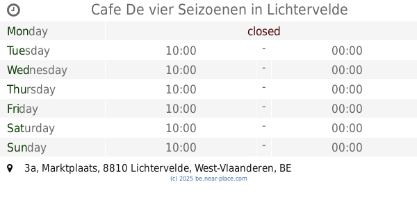
Cafe De vier Seizoenen
Marktplaats 3a, Lichtervelde
Cafe
read more
3.223 km
De Boksneuze
Statieplaats 8, Lichtervelde
Cafe
read more
3.242 km
Cafe T Wit Paard
Statieplaats 12, Lichtervelde
Cafe
read more
3.335 km
Raes-Vandenberghe / W.
Stationsstraat 73, Hooglede
Cafe
read more
3.406 km
Gasthof Djings
Beversesteenweg 503, Roeselare
Cafe
read more
3.501 km
Bourgondisch Kruis
Beversesteenweg 470, Roeselare
Cafe
read more
3.829 km
Devooght / Hans
Torhoutstraat 17, Hooglede
Cafe
read more
3.905 km
Lagrou / Frank
Grijspeerdstraat 1, Hooglede
Cafe
read more
4.372 km
Bistro
Gitsestraat 420, Roeselare
Cafe
read more
4.439 km
maxice
Brugsesteenweg 304, Roeselare
Cafe
read more
4.896 km
Café De Vierweg
Ardooisesteenweg, Roeselare
Cafe
read more
4.993 km
cafe colibri
Gitsestraat 280, Roeselare
Cafe
read more
5.281 km
De Elleboog
Brugsesteenweg 179, Roeselare
Cafe
read more
5.656 km
Vervoer Optima
Stadenkouter 12, Roeselare
Cafe
read more
5.676 km
concurent1
Wijnendalestraat 15, Roeselare
Cafe
read more
6.774 km
Rodenbachbolders
Veldstraat, Roeselare
Cafe
read more
7.6 km
Den Hazelt
Pastoor Slossestraat, Roeselare
Cafe
read more
9.013 km
De Nieuwe Wijk
Ardooisestraat 9, Izegem
Cafe
read more
12.361 km
't Hooghuis
Markt 19, Tielt
Cafe
read more
📑
all categories
Accounting
Administrative area level 1
Administrative area level 2
Airport
Amusement park
Aquarium
Art gallery
Atm
Bakery
Bank
Bar
Beauty salon
Bicycle store
Book store
Bowling alley
Bus station
Cafe
Campground
Car dealer
Car rental
Car repair
Car wash
Casino
Cemetery
Church
City hall
Clothing store
Colloquial area
Convenience store
Country
Courthouse
Dentist
Department store
Doctor
Electrician
Electronics store
Embassy
Finance
Fire station
Florist
Food
Funeral home
Furniture store
Gas station
General contractor
Grocery or supermarket
Gym
Hair care
Hardware store
Health
Hindu Temple
Home goods store
Hospital
Insurance agency
Jewelry store
Laundry
Lawyer
Library
Light rail station
Liquor store
Local government office
Locality
Locksmith
Lodging
Meal delivery
Meal takeaway
Mosque
Movie rental
Movie theater
Moving company
Museum
Natural feature
Neighborhood
Night club
Painter
Park
Parking
Pet store
Pharmacy
Physiotherapist
Place of worship
Plumber
Point of interest
Police
Political
Post office
Premise
Real estate agency
Restaurant
Roofing contractor
Route
Rv park, camping
School
Shoe store
Shopping mall
Spa
Stadium
Storage
Store
Subpremise
Subway station
Supermarket
Synagogue
Taxi stand
Train station
Transit station
Travel agency
University
Veterinary care
Zoo
sublocality level 1
sublocality level 2
sublocality level 3
↑