Cafe nearby Karsmakers Coffee House
Coronavirus disease (COVID-19) Situation
confirmed cases
4861695
deaths
34376
Belgium
Cafe nearby Karsmakers Coffee House
Karsmakers Coffee House
20, Rue de Trèves, 1050, Ixelles, BE Belgia
contacts phone
:
+32
website:
www.karsmakers.be
Latitude:
50.8383485
, Longitude:
4.3727441
larger map & directions
read more
nearest Cafe
131 m
Charles / Philippe
Luxemburgplein 12, Elsene
Cafe
read more
133 m
Tout Bon
Rue du Luxembourg 68, Bruxelles
Cafe
read more
154 m
Corica Quartier Européen
Carolystraat 39, Elsene
Cafe
read more
154 m
Corica Quartier Européen
Rue Caroly 39, Ixelles
Cafe
read more
413 m
Caffelatte Espressobar
Handelsstraat 19, Brussel
Cafe
read more
552 m
Aux Sans Souci
Rue du Viaduc Rue du Viaduc, Ixelles
Cafe
read more
575 m
Bar Athénée
Jules Bouillonstraat 2, Elsene
Cafe
read more
582 m
CaféVaria
Scepterstraat 78, Elsene
Cafe
read more
585 m
Cherry Delicatessen
Steenweg op Etterbeek 66, Brussel
Cafe
read more
625 m
Studio Frankie
Place Jourdan 13a, Etterbeek
Cafe
read more
685 m
Cafe Le Coq
Fernand Cocqplein 25, Elsene
Cafe
read more
757 m
Regence (La)
Fernand Cocqplein 12, Elsene
Cafe
read more
786 m
Chilli's Food - Maelbeek
Rue Joseph II 96, Bruxelles
Cafe
read more
832 m
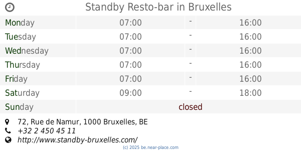
Standby Resto-bar
Rue de Namur 72, Bruxelles
Cafe
read more
834 m
Bruxelles Luxembourg
Gulden-Vlieslaan 11, Brussel
Cafe
read more
855 m
Starbucks
Robert Schumanplein, Brussel
Cafe
read more
869 m
Kiosk Radio
Place des Palais 10, Bruxelles
Cafe
read more
887 m
Brassin ( Le)
Keienveldstraat 36, Elsene
Cafe
read more
903 m
Brasserie 1898
Oudergemlaan 4, Brussel
Cafe
read more
928 m
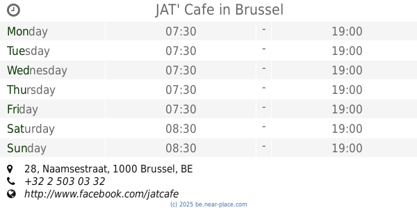
JAT' Cafe
Rue de Namur 28, Bruxelles
Cafe
read more
928 m
JAT' Cafe
Naamsestraat 28, Brussel
Cafe
read more
1.107 km
Cafe Felix
Chaussée de Wavre 558, Etterbeek
Cafe
read more
1.16 km
Laurent Gerbaud
Rue Ravenstein 12, Bruxelles
Cafe
read more
1.235 km
Workshop Café
Avenue Louise 146, Ixelles
Cafe
read more
1.358 km
Atelier En Ville
Rue de Livourne 51, Ixelles
Cafe
read more
📑
all categories
Accounting
Administrative area level 1
Administrative area level 2
Airport
Amusement park
Aquarium
Art gallery
Atm
Bakery
Bank
Bar
Beauty salon
Bicycle store
Book store
Bowling alley
Bus station
Cafe
Campground
Car dealer
Car rental
Car repair
Car wash
Casino
Cemetery
Church
City hall
Clothing store
Colloquial area
Convenience store
Country
Courthouse
Dentist
Department store
Doctor
Electrician
Electronics store
Embassy
Finance
Fire station
Florist
Food
Funeral home
Furniture store
Gas station
General contractor
Grocery or supermarket
Gym
Hair care
Hardware store
Health
Hindu Temple
Home goods store
Hospital
Insurance agency
Jewelry store
Laundry
Lawyer
Library
Light rail station
Liquor store
Local government office
Locality
Locksmith
Lodging
Meal delivery
Meal takeaway
Mosque
Movie rental
Movie theater
Moving company
Museum
Natural feature
Neighborhood
Night club
Painter
Park
Parking
Pet store
Pharmacy
Physiotherapist
Place of worship
Plumber
Point of interest
Police
Political
Post office
Premise
Real estate agency
Restaurant
Roofing contractor
Route
Rv park, camping
School
Shoe store
Shopping mall
Spa
Stadium
Storage
Store
Subpremise
Subway station
Supermarket
Synagogue
Taxi stand
Train station
Transit station
Travel agency
University
Veterinary care
Zoo
sublocality level 1
sublocality level 2
sublocality level 3
↑