Cafe nearby De 5 wegen Westrozebeke
Belgium
Cafe nearby De 5 wegen Westrozebeke
De 5 wegen Westrozebeke
Ontmijnersstraat 2, Staden België
contacts phone
:
+32
Latitude:
50.948968
, Longitude:
2.974893
read more
nearest Cafe
2.956 km
De Weunwaegne
Ieperstraat 166, Staden
Cafe
read more
3.217 km
In Den Bottle
Dorpsstraat 68, Staden
Cafe
read more
3.374 km
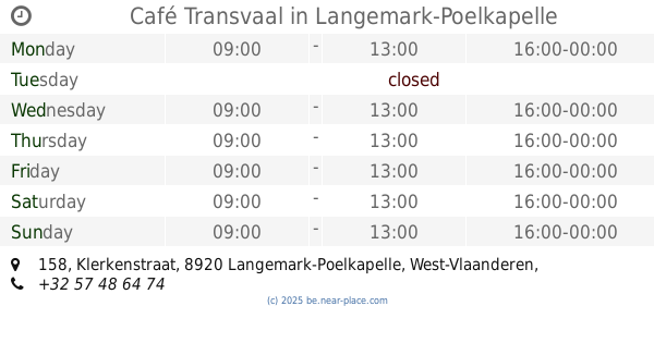
Café Transvaal
Klerkenstraat 158, Langemark-Poelkapelle
Cafe
read more
3.541 km
Het swingcafé
Brugseweg 130, Langemark-Poelkapelle
Cafe
read more
3.573 km
LDC De Schakel
Broeders Xaverianenstraat 10-14, Houthulst
Cafe
read more
3.588 km
Headquarter Trimard Classic
Klerkenstraat 142-126,8920, Langemark-Poelkapelle
Cafe
read more
3.629 km
't Oud Gemeentehuis Poelkapelle
Guynemerplein 5, Poelkapelle
Cafe
read more
3.673 km
Den Trimard
Markt 2, Houthulst
Cafe
read more
3.92 km
Café taboe
Grote Veldstraat, Staden
Cafe
read more
4.137 km
Sintobin-Pieters / I.
Klerkenstraat 34, Houthulst
Cafe
read more
4.408 km
Marchand / Denise
Vijverstraat 74, Houthulst
Cafe
read more
4.549 km
'T Vijverbos
Vijverbosstraat 18, Staden
Cafe
read more
4.943 km
Prinzie / Josiane
Merkemstraat 1, Houthulst
Cafe
read more
5.141 km
Café Luxor
Steenbeekstraat, Houthulst
Cafe
read more
5.544 km
Café Mosselmarkt
's Graventafelstraat 24, Zonnebeke
Cafe
read more
5.732 km
Frontduif (De)
Boezingestraat 40, Langemark-Poelkapelle
Cafe
read more
5.732 km
Frontduve
Boezingestraat 40, Langemark-Poelkapelle
Cafe
read more
5.843 km
De Bascule
Bikschotestraat 2-12, Langemark-Poelkapelle
Cafe
read more
5.931 km
Sportkaffee Eleven
Boezingestraat 51A, Langemark
Cafe
read more
9.74 km
Eetkaffee Steenstraete
Provincieweg 2, Langemark-Poelkapelle
Cafe
read more
9.946 km
concurent1
Wijnendalestraat 15, Roeselare
Cafe
read more
10.637 km
Rodenbachbolders
Veldstraat, Roeselare
Cafe
read more
13.703 km
Spearhead
Beselarestraat 43-1, Moorslede
Cafe
read more
15.017 km
Café De Slachter
Kerkplein, Ieper
Cafe
read more
16.603 km
Demey-Gouwy Mw / A.
Dikkebusseweg 401
Cafe
read more
📑
all categories
Accounting
Administrative area level 1
Administrative area level 2
Airport
Amusement park
Aquarium
Art gallery
Atm
Bakery
Bank
Bar
Beauty salon
Bicycle store
Book store
Bowling alley
Bus station
Cafe
Campground
Car dealer
Car rental
Car repair
Car wash
Casino
Cemetery
Church
City hall
Clothing store
Colloquial area
Convenience store
Country
Courthouse
Dentist
Department store
Doctor
Electrician
Electronics store
Embassy
Finance
Fire station
Florist
Food
Funeral home
Furniture store
Gas station
General contractor
Grocery or supermarket
Gym
Hair care
Hardware store
Health
Hindu Temple
Home goods store
Hospital
Insurance agency
Jewelry store
Laundry
Lawyer
Library
Light rail station
Liquor store
Local government office
Locality
Locksmith
Lodging
Meal delivery
Meal takeaway
Mosque
Movie rental
Movie theater
Moving company
Museum
Natural feature
Neighborhood
Night club
Painter
Park
Parking
Pet store
Pharmacy
Physiotherapist
Place of worship
Plumber
Point of interest
Police
Political
Post office
Premise
Real estate agency
Restaurant
Roofing contractor
Route
Rv park, camping
School
Shoe store
Shopping mall
Spa
Stadium
Storage
Store
Subpremise
Subway station
Supermarket
Synagogue
Taxi stand
Train station
Transit station
Travel agency
University
Veterinary care
Zoo
sublocality level 1
sublocality level 2
sublocality level 3
↑