Cafe nearby Cafe De Pits
Belgium
Cafe nearby Cafe De Pits
Cafe De Pits
Zuidstraat, Roeselare Belgium
contacts phone
:
+32
Latitude:
50.9425825
, Longitude:
3.1244719
read more
nearest Cafe
33 m
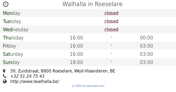
Walhalla
Zuidstraat 30, Roeselare
Cafe
read more
209 m
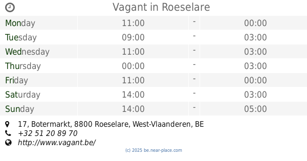
Vagant
Botermarkt 17, Roeselare
Cafe
read more
230 m
De Sjampetter
Botermarkt 13, Roeselare
Cafe
read more
242 m
Rodenbachbolders
Veldstraat, Roeselare
Cafe
read more
246 m
Bistro Botanique bvba
Polenplein 8, Roeselare
Cafe
read more
250 m
Huis Fragé bvba
Grote Markt 8, Roeselare
Cafe
read more
268 m
Cafe Cirque
Polenplein 4, Roeselare
Cafe
read more
322 m
Mokkabar
Wallenstraat 21, Roeselare
Cafe
read more
348 m
K-Trolle VZW
Scharestraat 18, Roeselare
Cafe
read more
366 m
Irish Tunes, Café
Sint-Alfonsusstraat 10, Roeselare
Cafe
read more
366 m
M.p.n.c.
Sint-Alfonsusstraat 10, Roeselare
Cafe
read more
423 m
Café De Bolle
Hof van Het Henneken 88, Roeselare
Cafe
read more
423 m
Vangheluwe / Christel
Hof van Het Henneken 88, Roeselare
Cafe
read more
463 m
The Lodge CV
Koning Albert I-laan 68, Roeselare
Cafe
read more
488 m
Het Bourgondisch Kruis
Noordstraat 59, Roeselare
Cafe
read more
491 m
Kindt-Lein / Marnik
Hippoliet Spilleboutdreef 14, Roeselare
Cafe
read more
557 m
De Mooie Molen
Meenseheirweg 39, Roeselare
Cafe
read more
558 m
De Nieuwe Gilde
Henri Horriestraat 31, Roeselare
Cafe
read more
628 m
Tina's
Hendrik Consciencestraat 16, Roeselare
Cafe
read more
655 m
Sanseveria
Veldstraat 61, Roeselare
Cafe
read more
671 m
in den Eekhoorn
Stationsplein 1, Roeselare
Cafe
read more
679 m
Café Dino
Kaaistraat 10, Roeselare
Cafe
read more
680 m
Bij Alain....Cafė Spoor5
Hendrik Consciencestraat 45, Roeselare
Cafe
read more
867 m
Steen / Francis
Kattenstraat 133, Roeselare
Cafe
read more
1.369 km
cafe rb
Ardooisesteenweg 215-165, Roeselare
Cafe
read more
📑
all categories
Accounting
Administrative area level 1
Administrative area level 2
Airport
Amusement park
Aquarium
Art gallery
Atm
Bakery
Bank
Bar
Beauty salon
Bicycle store
Book store
Bowling alley
Bus station
Cafe
Campground
Car dealer
Car rental
Car repair
Car wash
Casino
Cemetery
Church
City hall
Clothing store
Colloquial area
Convenience store
Country
Courthouse
Dentist
Department store
Doctor
Electrician
Electronics store
Embassy
Finance
Fire station
Florist
Food
Funeral home
Furniture store
Gas station
General contractor
Grocery or supermarket
Gym
Hair care
Hardware store
Health
Hindu Temple
Home goods store
Hospital
Insurance agency
Jewelry store
Laundry
Lawyer
Library
Light rail station
Liquor store
Local government office
Locality
Locksmith
Lodging
Meal delivery
Meal takeaway
Mosque
Movie rental
Movie theater
Moving company
Museum
Natural feature
Neighborhood
Night club
Painter
Park
Parking
Pet store
Pharmacy
Physiotherapist
Place of worship
Plumber
Point of interest
Police
Political
Post office
Premise
Real estate agency
Restaurant
Roofing contractor
Route
Rv park, camping
School
Shoe store
Shopping mall
Spa
Stadium
Storage
Store
Subpremise
Subway station
Supermarket
Synagogue
Taxi stand
Train station
Transit station
Travel agency
University
Veterinary care
Zoo
sublocality level 1
sublocality level 2
sublocality level 3
↑