Cafe nearby Café De Groeneweg
Coronavirus disease (COVID-19) Situation
confirmed cases
4861695
deaths
34376
Belgium
Cafe nearby Café De Groeneweg
Café De Groeneweg
Aalstersesteenweg 75, Ninove Belgium
contacts phone
:
+32
Latitude:
50.8423208
, Longitude:
4.0247872
read more
nearest Cafe
609 m
Sint-Annakamer
Biezenstraat 20, Ninove
Cafe
read more
724 m
Culture Pub
Graanmarkt 12, Ninove
Cafe
read more
727 m
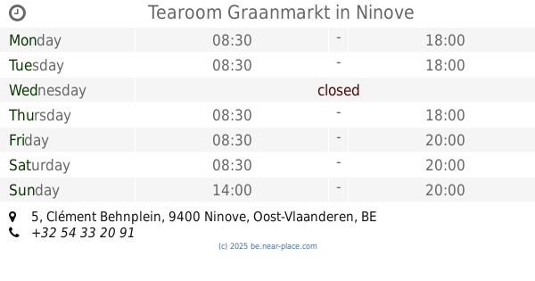
Tearoom Graanmarkt
Clément Behnplein 5, Ninove
Cafe
read more
763 m
Prohibiton Ninove
Geraardsbergsestraat 23, Ninove
Cafe
read more
770 m
The Trappist Bvba
Graanmarkt 49, Ninove
Cafe
read more
770 m
Den Trappist
Graanmarkt 49, Ninove
Cafe
read more
785 m
Cafe Ragtime
Langemuntstraat 9, Ninove
Cafe
read more
788 m
Gambrinus
Oudstrijdersplein 7, Ninove
Cafe
read more
789 m
Ragtime
Langemuntstraat 9, Ninove
Cafe
read more
793 m
‘t Kaffee
Markt 16, Zele
Cafe
read more
797 m
Kaai Stadslabo
Oude Kaai 11, Ninove
Cafe
read more
807 m
Roosevelt
Oudstrijdersplein 13, Ninove
Cafe
read more
809 m
Zaal Violon ( Roosevelt )
Oudstrijdersplein 13, Ninove
Cafe
read more
814 m
Café De Nieuwe Klok
Graanmarkt 2, Ninove
Cafe
read more
822 m
't Café
Graanmarkt 15, Ninove
Cafe
read more
823 m
Tea-Room Martinique
Albertlaan 166, Ninove
Cafe
read more
825 m
Den Drippel Bvba
Geraardsbergsestraat 64, Ninove
Cafe
read more
859 m
Cheers
Geraardsbergsestraat 69, Ninove
Cafe
read more
860 m
Bistrot Carte Blanche
Kaardeloodstraat 97, Ninove
Cafe
read more
876 m
In den Keizer
Burchtstraat 9, Ninove
Cafe
read more
876 m
In the Emperor
Burchtstraat 9, Ninove
Cafe
read more
902 m
Café De Leste Zonde
Burchtstraat 30, Ninove
Cafe
read more
932 m
t' volkshuis de redding
Geraardsbergsestraat 115, Ninove
Cafe
read more
1.496 km
De Rop Guy
Brusselstraat 34, Ninove
Cafe
read more
1.582 km
De Rio
Brusselsesteenweg 19, Ninove
Cafe
read more
📑
all categories
Accounting
Administrative area level 1
Administrative area level 2
Airport
Amusement park
Aquarium
Art gallery
Atm
Bakery
Bank
Bar
Beauty salon
Bicycle store
Book store
Bowling alley
Bus station
Cafe
Campground
Car dealer
Car rental
Car repair
Car wash
Casino
Cemetery
Church
City hall
Clothing store
Colloquial area
Convenience store
Country
Courthouse
Dentist
Department store
Doctor
Electrician
Electronics store
Embassy
Finance
Fire station
Florist
Food
Funeral home
Furniture store
Gas station
General contractor
Grocery or supermarket
Gym
Hair care
Hardware store
Health
Hindu Temple
Home goods store
Hospital
Insurance agency
Jewelry store
Laundry
Lawyer
Library
Light rail station
Liquor store
Local government office
Locality
Locksmith
Lodging
Meal delivery
Meal takeaway
Mosque
Movie rental
Movie theater
Moving company
Museum
Natural feature
Neighborhood
Night club
Painter
Park
Parking
Pet store
Pharmacy
Physiotherapist
Place of worship
Plumber
Point of interest
Police
Political
Post office
Premise
Real estate agency
Restaurant
Roofing contractor
Route
Rv park, camping
School
Shoe store
Shopping mall
Spa
Stadium
Storage
Store
Subpremise
Subway station
Supermarket
Synagogue
Taxi stand
Train station
Transit station
Travel agency
University
Veterinary care
Zoo
sublocality level 1
sublocality level 2
sublocality level 3
↑