Bar nearby Taverne Manneken Pis
Coronavirus disease (COVID-19) Situation
confirmed cases
4861695
deaths
34376
Belgium
Bar nearby Taverne Manneken Pis
Taverne Manneken Pis
Lievevrouwbroerstraat 31-33, Brussel België
contacts phone
:
+32
Latitude:
50.8449312
, Longitude:
4.3496027
read more
nearest Bar
134 m
Café Charbon
Rue du Marché au Charbon 90, Bruxelles
Bar
read more
188 m
Bar A Brussels
Rue de l'Amigo 13, Bruxelles
Bar
read more
198 m
CANDANCE BAR
Plattesteen 18, Brussel
Bar
read more
212 m
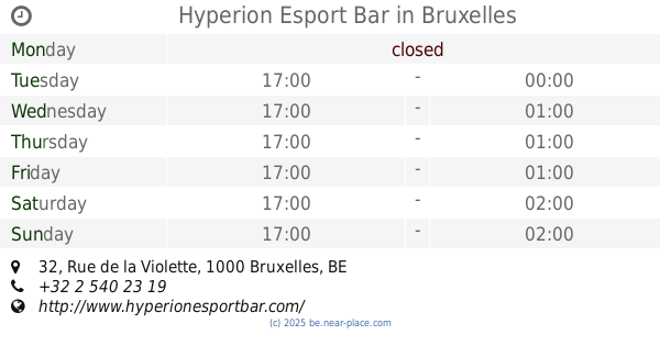
Hyperion Esport Bar
Rue de la Violette 32, Bruxelles
Bar
read more
275 m
le monte blue
Brussels
Bar
read more
275 m
le monte blue
Brussel
Bar
read more
320 m
Montechristo
Rue Henri Maus 6, Bruxelles
Bar
read more
414 m
Café Lava
Sint-Kristoffelsstraat 20, Brussel
Bar
read more
427 m
N.A.I.S Bar
Kapellemarkt 7, Brussel
Bar
read more
479 m
Taverne Greenwich Bruxellles
Rue des Chartreux 7, Bruxelles
Bar
read more
484 m
Coaster City
Rue des Dominicains 5, Bruxelles
Bar
read more
629 m
Scott's Bar
Warmoesberg 2, Brussel
Bar
read more
666 m
Leufo
Sint-Katelijneplein 5, Brussel
Bar
read more
691 m
moods
Koloniënstraat 6, Brussel
Bar
read more
724 m
Madame Moustache brussels
Quai au Bois à Brûler 5-7, Bruxelles
Bar
read more
727 m
Irish Céilí hosted by Belgium GAA
Rue de l'Epée 8, Bruxelles
Bar
read more
774 m
Centro Cabra Liego asbl
Hoogstraat 171, Brussel
Bar
read more
774 m
Centro Cabraliego
Hoogstraat 171, Brussel
Bar
read more
806 m
L'Arrêt 48
Rue Haute 187, Bruxelles
Bar
read more
848 m
Le Marais
Rue du Marais 3, Bruxelles
Bar
read more
876 m
Vismarkt
Brandhoutkaai 49, Brussel
Bar
read more
879 m
Pepete & Ronron
Léon Lepagestraat 53, Brussel
Bar
read more
955 m
La Plume de Pluim
Place du Jeu de Balle 33, Bruxelles
Bar
read more
955 m
La Plume de Pluim
Vossenplein 33, Brussel
Bar
read more
955 m
Le Cirque
26, Rue du Cirque 24, Bruxelles
Bar
read more
📑
all categories
Accounting
Administrative area level 1
Administrative area level 2
Airport
Amusement park
Aquarium
Art gallery
Atm
Bakery
Bank
Bar
Beauty salon
Bicycle store
Book store
Bowling alley
Bus station
Cafe
Campground
Car dealer
Car rental
Car repair
Car wash
Casino
Cemetery
Church
City hall
Clothing store
Colloquial area
Convenience store
Country
Courthouse
Dentist
Department store
Doctor
Electrician
Electronics store
Embassy
Finance
Fire station
Florist
Food
Funeral home
Furniture store
Gas station
General contractor
Grocery or supermarket
Gym
Hair care
Hardware store
Health
Hindu Temple
Home goods store
Hospital
Insurance agency
Jewelry store
Laundry
Lawyer
Library
Light rail station
Liquor store
Local government office
Locality
Locksmith
Lodging
Meal delivery
Meal takeaway
Mosque
Movie rental
Movie theater
Moving company
Museum
Natural feature
Neighborhood
Night club
Painter
Park
Parking
Pet store
Pharmacy
Physiotherapist
Place of worship
Plumber
Point of interest
Police
Political
Post office
Premise
Real estate agency
Restaurant
Roofing contractor
Route
Rv park, camping
School
Shoe store
Shopping mall
Spa
Stadium
Storage
Store
Subpremise
Subway station
Supermarket
Synagogue
Taxi stand
Train station
Transit station
Travel agency
University
Veterinary care
Zoo
sublocality level 1
sublocality level 2
sublocality level 3
↑