Bar nearby Maria
Belgium
Bar nearby Maria
Maria
Vooruitgangstraat 18-12, Oostende Bélgica
contacts phone
:
+32
Latitude:
51.2262054
, Longitude:
2.9257808
read more
nearest Bar
49 m
Romana
Oesterbankstraat 8400, Oostende
Bar
read more
52 m
Chounga
Fregatstraat 12, Oostende
Bar
read more
205 m
Marine Club Oostende VZW
Graaf de Smet de Naeyerlaan 46, Oostende
Bar
read more
710 m
Valentino
Sint-Franciscusstraat 29, Oostende
Bar
read more
744 m
La Vie
Kadzandstraat 14, Oostende
Bar
read more
748 m
De Crayon
Kadzandstraat 10, Oostende
Bar
read more
825 m
't Leeshuus
Groentemarkt 3, Oostende
Bar
read more
853 m
Het Mosselhuis
Nieuwstraat 14, Oostende
Bar
read more
965 m
Kelderke
Langestraat 71, Oostende
Bar
read more
972 m
Cosy Corner
Langestraat 76, Oostende
Bar
read more
977 m
Aperitivo Bar
Hertstraat 6, Oostende
Bar
read more
982 m
Poco Loco
Langestraat 45, Oostende
Bar
read more
1.004 km
Lafayette-Velghe
Madridstraat 10, Oostende
Bar
read more
1.013 km
ZEEGEUZEN
Kapucijnenstraat 42, Oostende
Bar
read more
1.016 km
Twilight Bvba
Langestraat 21, Oostende
Bar
read more
1.019 km
Manuscript
Langestraat 23, Oostende
Bar
read more
1.027 km
Hemingway
Langestraat 15, Oostende
Bar
read more
1.033 km
Lafayette Music Bar
Langestraat 12, Oostende
Bar
read more
1.079 km
Rood
Van Iseghemlaan 87, Oostende
Bar
read more
1.087 km
Eetcafe Belcante
Van Iseghemlaan 18, Oostende
Bar
read more
1.087 km
Maxim Cafe
Van Iseghemlaan 37, Oostende
Bar
read more
1.087 km
Maxin's
Van Iseghemlaan 37, Oostende
Bar
read more
1.094 km
Bar Baccara
Oostende
Bar
read more
1.094 km
Bar Baccara
Ostend
Bar
read more
1.193 km
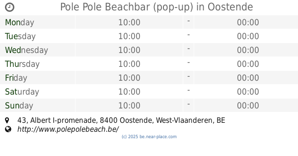
Pole Pole Beachbar (pop-up)
Albert I-promenade 43, Oostende
Bar
read more
📑
all categories
Accounting
Administrative area level 1
Administrative area level 2
Airport
Amusement park
Aquarium
Art gallery
Atm
Bakery
Bank
Bar
Beauty salon
Bicycle store
Book store
Bowling alley
Bus station
Cafe
Campground
Car dealer
Car rental
Car repair
Car wash
Casino
Cemetery
Church
City hall
Clothing store
Colloquial area
Convenience store
Country
Courthouse
Dentist
Department store
Doctor
Electrician
Electronics store
Embassy
Finance
Fire station
Florist
Food
Funeral home
Furniture store
Gas station
General contractor
Grocery or supermarket
Gym
Hair care
Hardware store
Health
Hindu Temple
Home goods store
Hospital
Insurance agency
Jewelry store
Laundry
Lawyer
Library
Light rail station
Liquor store
Local government office
Locality
Locksmith
Lodging
Meal delivery
Meal takeaway
Mosque
Movie rental
Movie theater
Moving company
Museum
Natural feature
Neighborhood
Night club
Painter
Park
Parking
Pet store
Pharmacy
Physiotherapist
Place of worship
Plumber
Point of interest
Police
Political
Post office
Premise
Real estate agency
Restaurant
Roofing contractor
Route
Rv park, camping
School
Shoe store
Shopping mall
Spa
Stadium
Storage
Store
Subpremise
Subway station
Supermarket
Synagogue
Taxi stand
Train station
Transit station
Travel agency
University
Veterinary care
Zoo
sublocality level 1
sublocality level 2
sublocality level 3
↑