Bar nearby De Drie Linden
Belgium
Bar nearby De Drie Linden
De Drie Linden
165, Stationsstraat, Rotselaar Belgia
contacts phone
:
+32
Latitude:
50.9443046
, Longitude:
4.7281577
read more
nearest Bar
2.348 km
Café Onder Den Toren - Bij Bele
Schoolstraat 57, Rotselaar
Bar
read more
3.243 km
Jeugdhuis Impuls
Vaartdijk 2, Leuven
Bar
read more
3.427 km
Snooker Fairplay
Pleinstraat 53b, Holsbeek
Bar
read more
3.583 km
Belgium-beer.be
Biekedelle 13, Holsbeek
Bar
read more
3.733 km
Rotselaar Algemeen, Hagelandse Academie Beeldende Kunst, Muziek & Woord
Sint Jansstraat 85, Werchter
Bar
read more
3.824 km
Café 'T Deurp
Werchterplein 35, Rotselaar
Bar
read more
3.88 km
't Hoeveke
Aarschotsesteenweg 334, Leuven
Bar
read more
4.509 km
Hof ten Dormaal
Caubergstraat 2, Haacht
Bar
read more
4.827 km
MaMuse bvba
Wilselsesteenweg 122, Lo
Bar
read more
6.601 km
De Lantaarn
Havenkant 18, Leuven
Bar
read more
6.755 km
Café Rocco
Diestsesteenweg 24, Leuven
Bar
read more
6.851 km
HAL 5
Locomotievenstraat, Leuven
Bar
read more
7.461 km
Carlisse
Arendstraat 1, Leuven
Bar
read more
7.463 km
Doc's Bar (fakbar van Medica)
Brusselsestraat 246, Leuven
Bar
read more
7.499 km
Chapter Four
Monseigneur Ladeuzeplein 31, Leuven
Bar
read more
7.513 km
cuythoek
Kapucijnenvoer 5, Leuven
Bar
read more
7.587 km
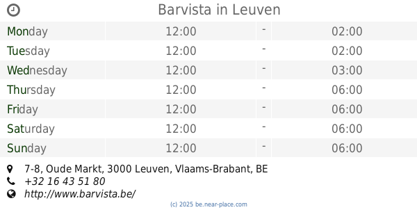
Barvista
Oude Markt 7-8, Leuven
Bar
read more
7.596 km
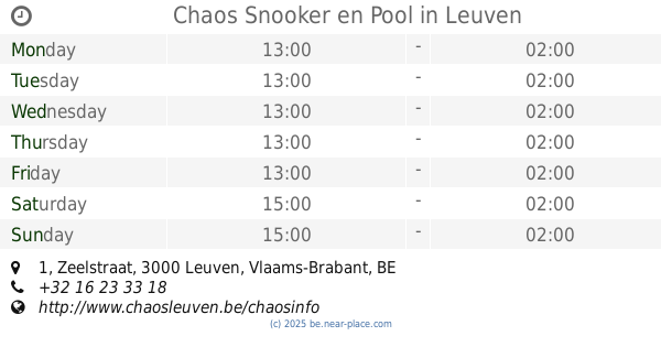
Chaos Snooker en Pool
Zeelstraat 1, Leuven
Bar
read more
7.606 km
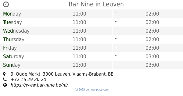
Bar Nine
Oude Markt 9, Leuven
Bar
read more
7.698 km
Café Manger
Oude Markt 29, Leuven
Bar
read more
7.701 km
Fakbar Dulci
Naamsestraat 34, Leuven
Bar
read more
7.708 km
Gainsbourg
Kardinaal Mercierplein 1, Leuven
Bar
read more
7.821 km
luak
Minderbroedersstraat, Leuven
Bar
read more
8.441 km
Bar Del Sol
Schapenstraat 105, Leuven
Bar
read more
8.588 km
't ElixIr
Tervuursevest 60, Leuven
Bar
read more
📑
all categories
Accounting
Administrative area level 1
Administrative area level 2
Airport
Amusement park
Aquarium
Art gallery
Atm
Bakery
Bank
Bar
Beauty salon
Bicycle store
Book store
Bowling alley
Bus station
Cafe
Campground
Car dealer
Car rental
Car repair
Car wash
Casino
Cemetery
Church
City hall
Clothing store
Colloquial area
Convenience store
Country
Courthouse
Dentist
Department store
Doctor
Electrician
Electronics store
Embassy
Finance
Fire station
Florist
Food
Funeral home
Furniture store
Gas station
General contractor
Grocery or supermarket
Gym
Hair care
Hardware store
Health
Hindu Temple
Home goods store
Hospital
Insurance agency
Jewelry store
Laundry
Lawyer
Library
Light rail station
Liquor store
Local government office
Locality
Locksmith
Lodging
Meal delivery
Meal takeaway
Mosque
Movie rental
Movie theater
Moving company
Museum
Natural feature
Neighborhood
Night club
Painter
Park
Parking
Pet store
Pharmacy
Physiotherapist
Place of worship
Plumber
Point of interest
Police
Political
Post office
Premise
Real estate agency
Restaurant
Roofing contractor
Route
Rv park, camping
School
Shoe store
Shopping mall
Spa
Stadium
Storage
Store
Subpremise
Subway station
Supermarket
Synagogue
Taxi stand
Train station
Transit station
Travel agency
University
Veterinary care
Zoo
sublocality level 1
sublocality level 2
sublocality level 3
↑