Bank nearby BNP Paribas Fortis Gent-Mariakerke
Coronavirus disease (COVID-19) Situation
confirmed cases
4861695
deaths
34376
Belgium
Bank nearby BNP Paribas Fortis Gent-Mariakerke
BNP Paribas Fortis Gent-Mariakerke
Brugsesteenweg 537, Gent Belgia
contacts phone
:
+32
Latitude:
51.0715785
, Longitude:
3.6806741
read more
nearest Bank
27 m
ING Bvba Kris Van Hove
Maurice Claeysplein 4, Gent
Bank
read more
41 m
Belfius - Mariakerke
Brugsesteenweg 514, Mariakerke (Gent)
Bank
read more
100 m
KBC
Brugsesteenweg 513, Mariakerke (gent)
Bank
read more
628 m
Argenta
Kollebloemstraat 37, Gent
Bank
read more
1.601 km
Beobank
Mimosastraat 178 A, Gent
Bank
read more
1.957 km
Rana Krediet BVBA
Francisco Ferrerlaan 256, Gent
Bank
read more
2.132 km
Bank van de Post
Emilius Seghersplein, Gent
Bank
read more
2.365 km
Record Bank - Vercammen Frank
Mariakerksesteenweg 44, Drongen
Bank
read more
2.394 km
Beobank
Wondelgemstraat 16, Gent
Bank
read more
2.512 km
Eb-lease
Nieuwewandeling 122, Gent
Bank
read more
2.52 km
Europabank
Nieuwewandeling 122, Gent
Bank
read more
2.597 km
ING
Drongenplein 6, Drongen
Bank
read more
2.62 km
Argenta Drongen
Vierhekkensstraat 3/A, Drongen
Bank
read more
2.675 km
BNP Paribas Fortis Drongen
Drongenplein 21, Drongen
Bank
read more
2.698 km
Belfius - Drongen
Oude-Abdijstraat 2, Drongen
Bank
read more
2.726 km
BNP Paribas Fortis Gent Kolveniersgang
Kolveniersgang 2, Gent
Bank
read more
2.902 km
Fintro Gent-Fintrest NV
Burgstraat 182, Gent
Bank
read more
3.2 km
Argenta Tratsaert Tom
Morekstraat 490, Gent
Bank
read more
3.252 km
Belfius Bank
Sint-Markoenstraat 1, Gent
Bank
read more
3.329 km
vdk bank
Sint-Michielsplein 16, Gent
Bank
read more
3.346 km
Argenta Spaarbank nv
Martelaarslaan 346, Gent
Bank
read more
3.657 km
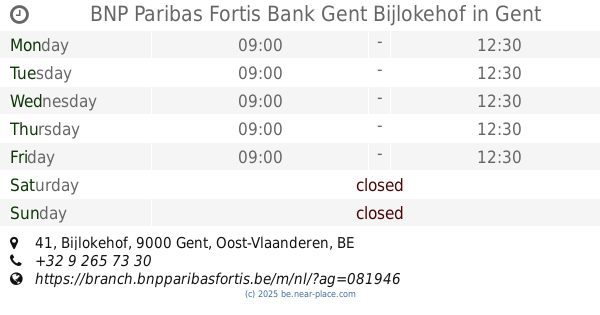
BNP Paribas Fortis Bank Gent Bijlokehof
Bijlokehof 41, Gent
Bank
read more
3.715 km
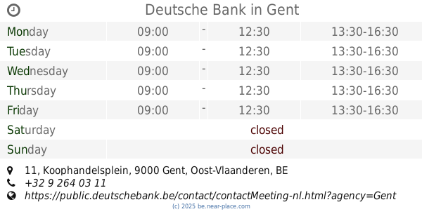
Deutsche Bank
Koophandelsplein 11, Gent
Bank
read more
3.715 km
Deutsche Bank Gent
Koophandelsplein 11, Gent
Bank
read more
3.744 km
Fortis Bank
Belfortstraat 41, Gent
Bank
read more
📑
all categories
Accounting
Administrative area level 1
Administrative area level 2
Airport
Amusement park
Aquarium
Art gallery
Atm
Bakery
Bank
Bar
Beauty salon
Bicycle store
Book store
Bowling alley
Bus station
Cafe
Campground
Car dealer
Car rental
Car repair
Car wash
Casino
Cemetery
Church
City hall
Clothing store
Colloquial area
Convenience store
Country
Courthouse
Dentist
Department store
Doctor
Electrician
Electronics store
Embassy
Finance
Fire station
Florist
Food
Funeral home
Furniture store
Gas station
General contractor
Grocery or supermarket
Gym
Hair care
Hardware store
Health
Hindu Temple
Home goods store
Hospital
Insurance agency
Jewelry store
Laundry
Lawyer
Library
Light rail station
Liquor store
Local government office
Locality
Locksmith
Lodging
Meal delivery
Meal takeaway
Mosque
Movie rental
Movie theater
Moving company
Museum
Natural feature
Neighborhood
Night club
Painter
Park
Parking
Pet store
Pharmacy
Physiotherapist
Place of worship
Plumber
Point of interest
Police
Political
Post office
Premise
Real estate agency
Restaurant
Roofing contractor
Route
Rv park, camping
School
Shoe store
Shopping mall
Spa
Stadium
Storage
Store
Subpremise
Subway station
Supermarket
Synagogue
Taxi stand
Train station
Transit station
Travel agency
University
Veterinary care
Zoo
sublocality level 1
sublocality level 2
sublocality level 3
↑