Bakery nearby Delrue B & M
Coronavirus disease (COVID-19) Situation
confirmed cases
4861695
deaths
34376
Belgium
Bakery nearby Delrue B & M
Delrue B & M
Tiensestraat 276, Leuven Belgique
contacts phone
:
+32
Latitude:
50.8735872
, Longitude:
4.7135892
read more
nearest Bakery
8 m
Au flan Breton
Tiensestraat 276, Leuven
Bakery
read more
309 m
Carrefour express
Burgemeesterstraat -, 36, Leuven
Bakery
read more
436 m
vangrootloon
Tiensestraat 121, Leuven
Bakery
read more
476 m
TITATOVERTAART
Tiensesteenweg 124, Leuven
Bakery
read more
561 m
Patisserie Nathalie
Tiensesteenweg 144, Leuven
Bakery
read more
605 m
Willems / Walter
Geldenaaksevest 122, Leuven
Bakery
read more
608 m
Bakkerij Willems
Geldenaaksevest 122, Leuven
Bakery
read more
625 m
Panem Lovanium
Bogaardenstraat 32, Leuven
Bakery
read more
719 m
Bakkerij Van Huyck- Vandenplas
Parkstraat 103, Leuven
Bakery
read more
746 m
Carrefour express
Weldadigheidsstraat 60, Leuven
Bakery
read more
834 m
Patisserie Nathalie
Karel Schurmansstraat 2, Leuven
Bakery
read more
889 m
Patisserie Dirk
Koning Albertlaan 166, Leuven
Bakery
read more
905 m
The Coffee Club
Martelarenplein 16, Leuven
Bakery
read more
935 m
Alexandre
Diestsestraat 234, Leuven
Bakery
read more
936 m
Deliway Kessel-Lo Tiense
Tiensesteenweg 235, Kessel-Lo
Bakery
read more
941 m
Carrefour Express
Tiensevest 10, Leuven
Bakery
read more
952 m
Carrefour express
Rector Pieter De Somerplein, 12, Leuven
Bakery
read more
952 m
Immobilière Dewit et Compagnie NV
Leopold Vanderkelenstraat 13, Leuven
Bakery
read more
958 m
Carrefour Express
Tiensesteenweg 235, Leuven
Bakery
read more
976 m
Carrefour Express
Naamsestraat 48, Leuven
Bakery
read more
1.058 km
Nosh
Naamsestraat 14, Leuven
Bakery
read more
1.06 km
Vangrootloon
Naamsestraat 12, Leuven
Bakery
read more
1.146 km
Deli Leuven Markt Bvba
Brusselsestraat 4, Leuven
Bakery
read more
1.239 km
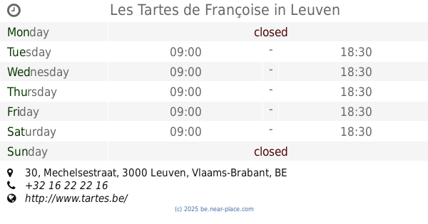
Les Tartes de Françoise - Leuven
Mechelsestraat 30, Leuven
Bakery
read more
1.239 km
Les Tartes de Françoise
Mechelsestraat 30, Leuven
Bakery
read more
📑
all categories
Accounting
Administrative area level 1
Administrative area level 2
Airport
Amusement park
Aquarium
Art gallery
Atm
Bakery
Bank
Bar
Beauty salon
Bicycle store
Book store
Bowling alley
Bus station
Cafe
Campground
Car dealer
Car rental
Car repair
Car wash
Casino
Cemetery
Church
City hall
Clothing store
Colloquial area
Convenience store
Country
Courthouse
Dentist
Department store
Doctor
Electrician
Electronics store
Embassy
Finance
Fire station
Florist
Food
Funeral home
Furniture store
Gas station
General contractor
Grocery or supermarket
Gym
Hair care
Hardware store
Health
Hindu Temple
Home goods store
Hospital
Insurance agency
Jewelry store
Laundry
Lawyer
Library
Light rail station
Liquor store
Local government office
Locality
Locksmith
Lodging
Meal delivery
Meal takeaway
Mosque
Movie rental
Movie theater
Moving company
Museum
Natural feature
Neighborhood
Night club
Painter
Park
Parking
Pet store
Pharmacy
Physiotherapist
Place of worship
Plumber
Point of interest
Police
Political
Post office
Premise
Real estate agency
Restaurant
Roofing contractor
Route
Rv park, camping
School
Shoe store
Shopping mall
Spa
Stadium
Storage
Store
Subpremise
Subway station
Supermarket
Synagogue
Taxi stand
Train station
Transit station
Travel agency
University
Veterinary care
Zoo
sublocality level 1
sublocality level 2
sublocality level 3
↑