Bakery nearby Cremello
Coronavirus disease (COVID-19) Situation
confirmed cases
4861695
deaths
34376
Belgium
Bakery nearby Cremello
Cremello
Ronsesestraat 251, Brakel België
contacts phone
:
+32
Latitude:
50.7821721
, Longitude:
3.7173416
read more
nearest Bakery
1.595 km
Van Der Linden sprl
D'Hoppe 43, Vloesberg
Bakery
read more
2.219 km
DUMONT
D'Hoppe 48, Vloesberg
Bakery
read more
2.219 km
Dumont / Etienne
D'Hoppe 48, Vloesberg
Bakery
read more
3.268 km
Collet / Jean
Pierestraat 15, Maarkedal
Bakery
read more
3.467 km
Cremello Bvba
Rondplein 5, Brakel
Bakery
read more
3.926 km
De Lekkerbek Brakel - Deneyer / Peter
Kasteelstraat 15, Brakel
Bakery
read more
3.992 km
Thijs Bakkerij
Stationsstraat 91, Brakel
Bakery
read more
4.032 km
Goubert / Koen
Wielendaalstraat 67, Brakel
Bakery
read more
4.062 km
Delabre Roland
Rue Planche 65, Flobecq
Bakery
read more
4.229 km
Retro (bakkerij)
Muiterij 18, Brakel
Bakery
read more
5.249 km
Picalausa T.
Place 28, Flobecq
Bakery
read more
7.678 km
Peter & Sofie
Ninovestraat 211, Ronse
Bakery
read more
7.911 km
Bakkerij Waegeman
Sint-Hubertusplein 35, Zottegem
Bakery
read more
8.956 km
Bakkerij Dubart Boulangerie
Zuidstraat 38, Ronse
Bakery
read more
11.226 km
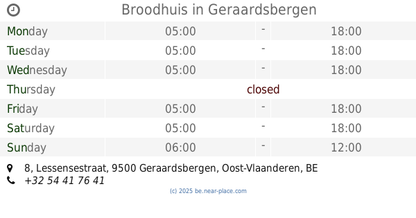
Broodhuis
Lessensestraat 8, Geraardsbergen
Bakery
read more
11.584 km
Broodautomaat
Hoogstraat 19, Zwalm
Bakery
read more
11.618 km
Nevens / Pascal
Boelarestraat 38, Geraardsbergen
Bakery
read more
11.696 km
Bakkerij Taerwe
Nestor de Tièrestraat 12, Oudenaarde
Bakery
read more
13.66 km
Bakkerij Mathias en Nathalie
Eikestraat 5, Steenhuize
Bakery
read more
14.432 km
Van Belle
Moerbekeplein 1, Geraardsbergen
Bakery
read more
14.622 km
Bakery François and Anne-Gaëlle
Rue des Combattants 69, Lessines
Bakery
read more
14.962 km
Bakkerij/Tearoom Broodnodig
Kauwstraat 42, Herzele
Bakery
read more
15.591 km
Janssens / Gerarda
Carlos Dierickxplein 2, Gavere
Bakery
read more
15.867 km
De Wolf / J.
Lauwveldweg 3, Herzele
Bakery
read more
17.23 km
Bakkerij Boerjan
Stationsstraat 168, Herzele
Bakery
read more
📑
all categories
Accounting
Administrative area level 1
Administrative area level 2
Airport
Amusement park
Aquarium
Art gallery
Atm
Bakery
Bank
Bar
Beauty salon
Bicycle store
Book store
Bowling alley
Bus station
Cafe
Campground
Car dealer
Car rental
Car repair
Car wash
Casino
Cemetery
Church
City hall
Clothing store
Colloquial area
Convenience store
Country
Courthouse
Dentist
Department store
Doctor
Electrician
Electronics store
Embassy
Finance
Fire station
Florist
Food
Funeral home
Furniture store
Gas station
General contractor
Grocery or supermarket
Gym
Hair care
Hardware store
Health
Hindu Temple
Home goods store
Hospital
Insurance agency
Jewelry store
Laundry
Lawyer
Library
Light rail station
Liquor store
Local government office
Locality
Locksmith
Lodging
Meal delivery
Meal takeaway
Mosque
Movie rental
Movie theater
Moving company
Museum
Natural feature
Neighborhood
Night club
Painter
Park
Parking
Pet store
Pharmacy
Physiotherapist
Place of worship
Plumber
Point of interest
Police
Political
Post office
Premise
Real estate agency
Restaurant
Roofing contractor
Route
Rv park, camping
School
Shoe store
Shopping mall
Spa
Stadium
Storage
Store
Subpremise
Subway station
Supermarket
Synagogue
Taxi stand
Train station
Transit station
Travel agency
University
Veterinary care
Zoo
sublocality level 1
sublocality level 2
sublocality level 3
↑