Bakery nearby Brood & Zoet Schrijvers
Coronavirus disease (COVID-19) Situation
confirmed cases
4861695
deaths
34376
Belgium
Bakery nearby Brood & Zoet Schrijvers
Brood & Zoet Schrijvers
28, Grotestraat, 3600, Genk, Limburg, BE Belgium
contacts phone
:
+32 89 35 33 54
website:
broodenzoet.be
Latitude:
50.963554
, Longitude:
5.4963893
larger map & directions
read more
nearest Bakery
354 m
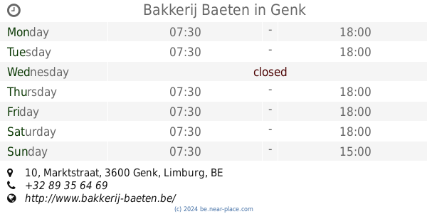
Bakkerij Baeten
Marktstraat 10, Genk
Bakery
read more
406 m
Geebelen
Stationsstraat 32, Genk
Bakery
read more
451 m
Koffiekoekje ('T)
Rootenstraat 21, Genk
Bakery
read more
503 m
Dirix Banketbakker M.
Bochtlaan 1, Genk
Bakery
read more
638 m
Hypermarkt Carrefour GENK
Rootenstraat 8, Genk
Bakery
read more
638 m
hypermarkt Carrefour
Rootenstraat 8, Genk
Bakery
read more
638 m
Hypermarket Carrefour GENK
Rootenstraat 8, Genk
Bakery
read more
706 m
Patisserie Brabanders
Nieuwstraat 120, Genk
Bakery
read more
759 m
Fabiano / Domenico
Rozenkranslaan 26, Genk
Bakery
read more
759 m
Bakkerij Dana
Rozenkranslaan 26, Genk
Bakery
read more
855 m
Carrefour Express
Nieuwe Kuilenweg 2, Genk
Bakery
read more
1.2 km
Bij den Bakker Genk
Rozenkranslaan 148, Genk
Bakery
read more
1.346 km
Koek (en) brood
6 bus 2, Tennislaan, Genk
Bakery
read more
1.407 km
Deliway Genk
Hasseltweg 12/14, Genk
Bakery
read more
1.409 km
Deliway Genk
Hasseltweg 12-14, Genk
Bakery
read more
1.714 km
De Korenaar hoogstraat
Weg naar As 160, Genk
Bakery
read more
1.745 km
Bakkerij Goiris
Vennestraat 120, Genk
Bakery
read more
1.806 km
Stassen-Wijnen / J.
Hoefstadstraat 75, Genk
Bakery
read more
1.825 km
Put-Froyen
Vennestraat 141, Genk
Bakery
read more
1.952 km
Budgetbakker
Genk
Bakery
read more
2.122 km
't Koffiekoekje
Collegelaan 18, Genk
Bakery
read more
2.249 km
Brood & Zoet Schrijvers
Spoorwegstraat 9, Genk
Bakery
read more
2.391 km
Bakkerij Snijkers
Weg naar As 234, Genk
Bakery
read more
2.391 km
Bakery Snijkers
Weg naar As 234, Genk
Bakery
read more
3.219 km
Bakkerij Deneubourg
Landwaartslaan 14, Genk
Bakery
read more
📑
all categories
Accounting
Administrative area level 1
Administrative area level 2
Airport
Amusement park
Aquarium
Art gallery
Atm
Bakery
Bank
Bar
Beauty salon
Bicycle store
Book store
Bowling alley
Bus station
Cafe
Campground
Car dealer
Car rental
Car repair
Car wash
Casino
Cemetery
Church
City hall
Clothing store
Colloquial area
Convenience store
Country
Courthouse
Dentist
Department store
Doctor
Electrician
Electronics store
Embassy
Finance
Fire station
Florist
Food
Funeral home
Furniture store
Gas station
General contractor
Grocery or supermarket
Gym
Hair care
Hardware store
Health
Hindu Temple
Home goods store
Hospital
Insurance agency
Jewelry store
Laundry
Lawyer
Library
Light rail station
Liquor store
Local government office
Locality
Locksmith
Lodging
Meal delivery
Meal takeaway
Mosque
Movie rental
Movie theater
Moving company
Museum
Natural feature
Neighborhood
Night club
Painter
Park
Parking
Pet store
Pharmacy
Physiotherapist
Place of worship
Plumber
Point of interest
Police
Political
Post office
Premise
Real estate agency
Restaurant
Roofing contractor
Route
Rv park, camping
School
Shoe store
Shopping mall
Spa
Stadium
Storage
Store
Subpremise
Subway station
Supermarket
Synagogue
Taxi stand
Train station
Transit station
Travel agency
University
Veterinary care
Zoo
sublocality level 1
sublocality level 2
sublocality level 3
↑